
Unmarked Cemeteries of London
In honour of October 31st (Halloween) and November 2nd (All Souls Day; Day of the Dead), TMHC reveals the lesser known, sometimes forgotten cemeteries of London, Ontario, based on Emily Heller’s 1987 preliminary report, Unmarked Cemeteries in the City of London.
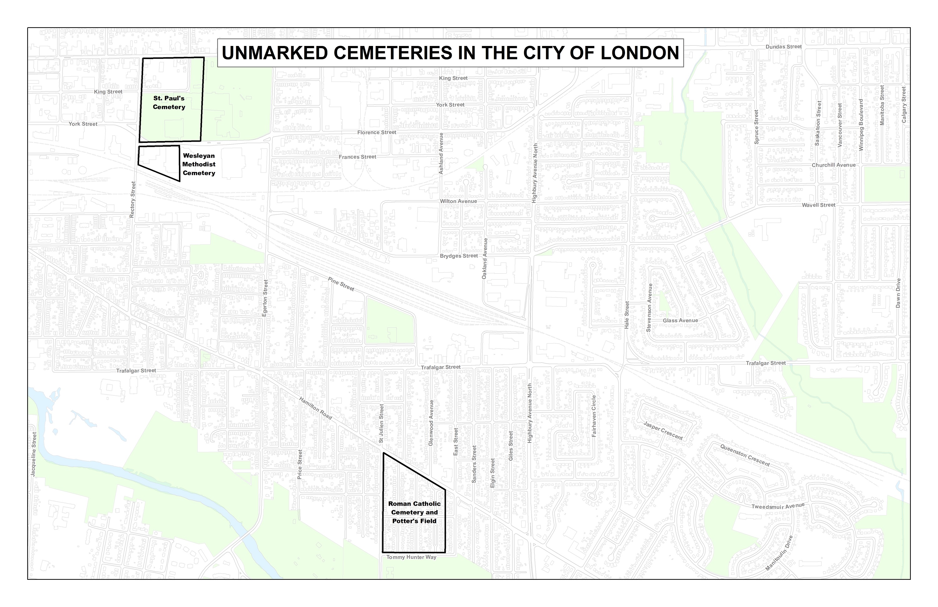
Heller located and researched 11 unmarked cemeteries in the city (Click the maps below to expand).
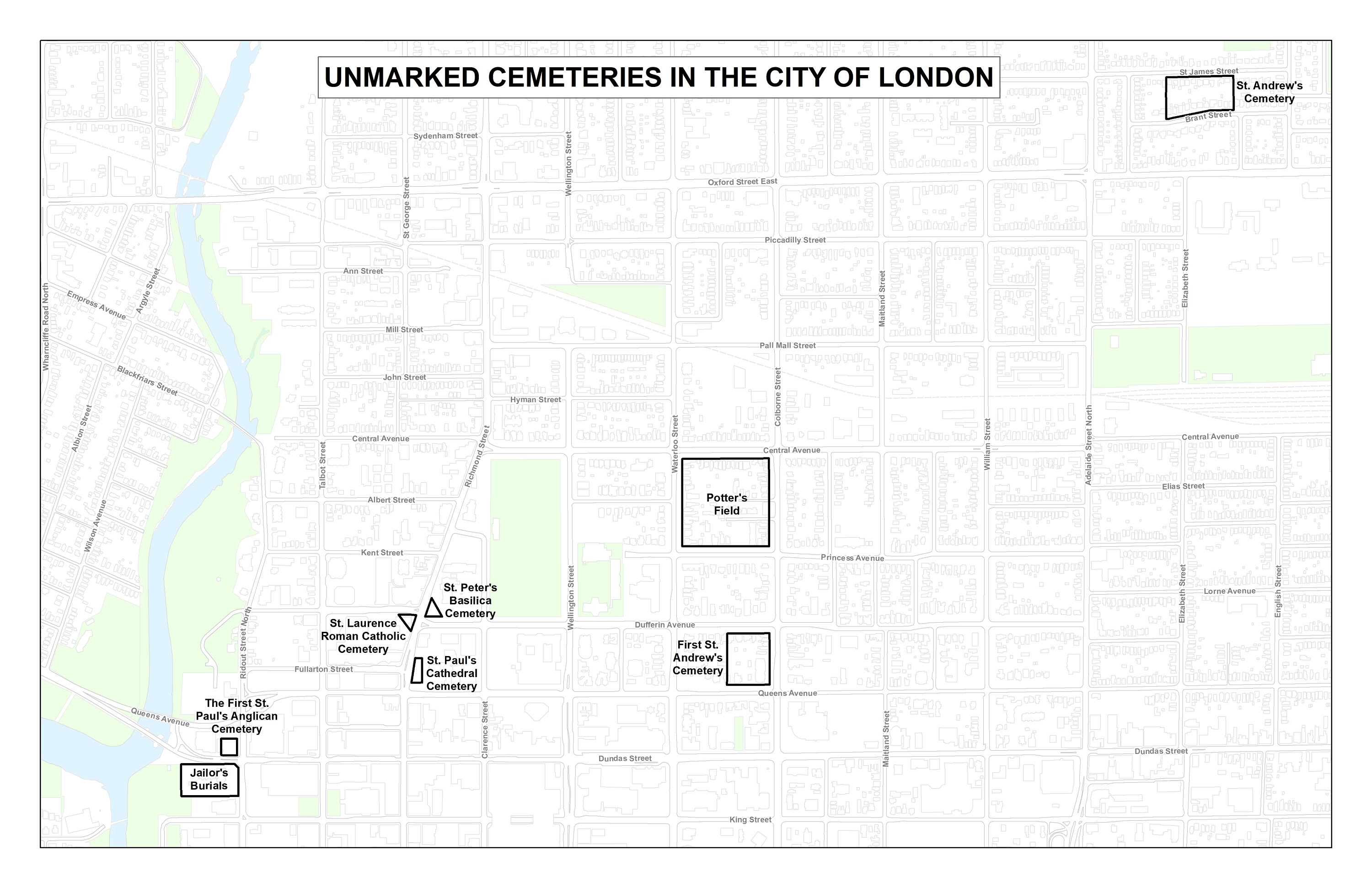
The First St. Paul’s Anglican Cemetery
Location: Northwest Corner of Dundas St. and Ridout St., currently Museum London
Opened: 1830
Closed: 1834
Before St. Paul’s Cathedral occupied its original location at Queens Ave. and Richmond St., the church was originally slated to be built on a property north of Dundas St. at Ridout. Although only ever a frame of a structure, the original plot did include a cemetery where some of London’s earliest European settlers were buried. Many were reinterred when the location moved, however later accounts suggested that unmarked burials were unable to be relocated and left in place (Dr. John Patrick Donnelly, Dr. E. Simpson’s wife and son, and the mother, sister and brother-in-law of Peter McGregor). These remaining burials consisted primarily of victims of London’s 1832 cholera epidemic. In 1925, two coffins were uncovered at the corner of Ridout and Carling St., at that time one block north. One of the skeletons was claimed to be that of Dr. Donnelly; both were reburied in Sarnia.
When Museum London was built in 1970, controversy ensued over the possible presence of the cemetery. With no study completed prior to development and no graves apparently uncovered during construction, it has been suggested that the cemetery remains either under the parking lot of Museum London or closer to the Thames River.
The Second St. Paul’s Anglican Cemetery
Location: Northeast Corner of Queens Ave. and Richmond St., currently St. Paul’s Anglican Cathedral
Opened: 1834
Closed: 1852
The transplanted occupants of the original St. Paul’s cemetery did not stay long in their new location. In 1849, a new city bylaw required that interments occur outside of city limits. In 1852, the cemetery relocated to its third location at the southeast corner of Dundas St. and Rectory St. Not everybody moved. The Ontario Genealogical Society recorded 14 marked graves still on-site. In 1968, construction south of Dufferin Ave. immediately north of the cathedral uncovered portions of four individuals believed to be part of the original cemetery suggesting any number of unmarked graves may also be present.
The Third St. Paul’s Anglican Cemetery
Location: Southeast corner of Dundas St. and Rectory St. extending south to Queen’s Park and south through the Western Fair Grounds to Florence St.
Opened: 1852
Closed: 1881
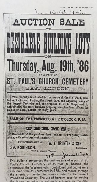
Covering a substantial portion of Western Fair and the block southeast of Dundas and Rectory, the third St. Paul’s Cemetery was significantly larger than its two previous iterations. When the cemetery was forced to relocate by the Village of London East in a 1880 by-law, it took six years to move over 8000 individuals to their current resting place at Woodland Cemetery. Records indicate at least part of the marked cemetery was intentionally left behind while any number of unmarked graves could also be present throughout the site.
Wesleyan Methodist Cemetery
Location: Southeast corner of Florence St. and Rectory St., currently Western Fair District offices and the Agriplex.
Opened: 1845
Closed: 1879
Moved to Mount Pleasant in 1879, the cessation of cemetery operations at this location foreshadowed the closing of St. Paul’s third cemetery immediately to the north. Like St. Paul’s, the Wesleyan trustees indicated that some known burials remained at the location in addition to an unknown number of graves which could not be relocated to transfer.
The First St. Andrew’s Church Cemetery
Location: Northeast corner of Queens Ave. and Waterloo St., currently First St. Andrew’s United Church.
Opened: 1843
Closed: 1856 (moved 1868)
The same 1849 by-law which moved the St. Paul’s Cemetery the second time, also led to the closing of this cemetery. The graves were relocated to a new property on St. James Street, two blocks east of Adelaide Street. Heller notes that the move is not documented and surmises there may still be unmarked graves at the Queens Ave. location.
The Second St. Andrew’s Church Cemetery
Location: South side of St. James Street two blocks east of Adelaide (more precise location unclear).
Opened: 1856
Closed: 1955
Also known as the Scottish Burial Ground, St. Andrew’s Cemetery’s second location was maintained until the 1920s when a period of neglect began. By 1954, the trustees responsible for the cemetery recommended its closure. In 1955, approximately 600 individuals and 150 headstones were relocated to Woodland Cemetery. The following year, children playing around the construction of new houses on the original cemetery discovered two human bones suggesting that the period of neglect may have resulted in graves being missed during the relocation.
St. Lawrence Roman Catholic Cemetery
Location: Southwest corner of Richmond St. and Maple St. (realigned to Dufferin Ave.)
Opened: 1830s
Closed: 1850s
The location of London’s first Roman Catholic Church built in the 1830s, the St. Lawrence Cemetery is presumed to have existed alongside the church. No records exist of the cemetery, though historians note that when the Grand Theatre was constructed, workmen uncovered a number of individuals. In 1970, impending roadwork and concern over the potential presence of the church and cemetery led to archaeological work which uncovered the original foundation and a single grave and headstone.
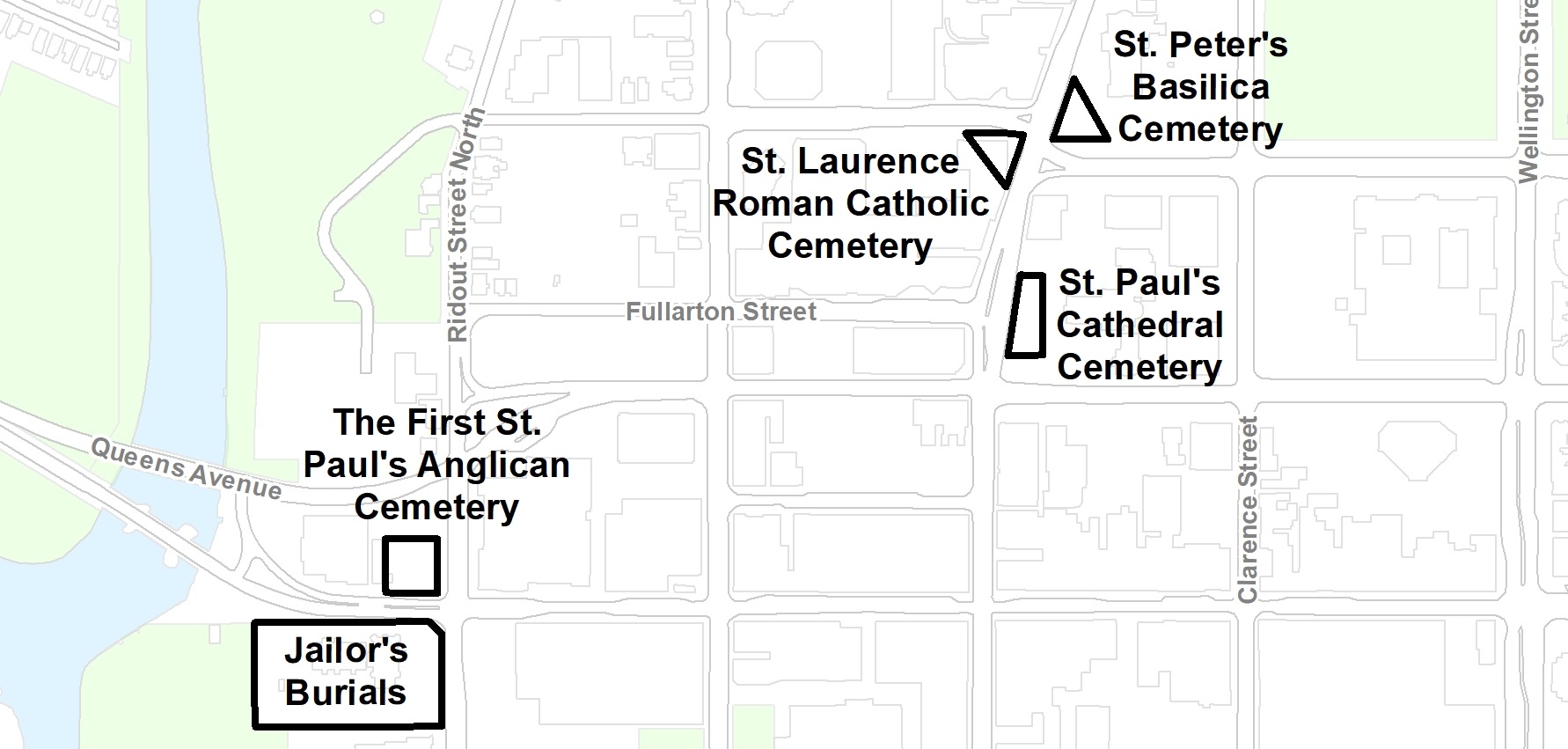
St. Peter’s Cathedral Cemetery
Location: Northeast corner of Richmond St. and Dufferin Ave., currently St. Peter’s Basilica.
Opened: early 1840s
Closed: 1857
When St. Lawrence burned down in 1851, the property across the street had already been serving as a Catholic cemetery since the before 1846. Burials continued after the new Catholic church, the original St. Peter’s, was constructed on these grounds. In 1857, active interments moved to St. Peter’s Cemetery on Huron Street. However, there are no records that the original cemetery was ever moved. In 1907, during work on St. Peter’s Separate School, approximately 30 individuals were uncovered. Only one tombstone, dating to 1852 was located. Despite subsequent excavations at St. Peter’s Basilica not finding other individuals, it is highly likely that more individuals remain on the property possibly further east along Clarence St. or south towards Dufferin. Heller’s report includes a list of some 152 individuals from church records buried between 1852 and 1857 at the cemetery.
Hamilton Road Cemeteries
Location: South side of Hamilton Road between St. Julian’s Street and East Street.
Opened: 1852 (est.)
Closed: 1857 (est.)
Between the 1930s and 1980s, seven or eight different individuals have been uncovered in this area, particularly around Delaware Street. Heller notes early records and literature suggest a Roman Catholic cemetery was briefly located on this parcel in the mid-19th century. The literature also suggests, without collaborating evidence, that the area immediately north of this parcel, still south of Hamilton, was also a cemetery: a Potter’s Field originating from an earlier St. Paul’s Church of England Cemetery. It is suggested that a hospital also occupied the grounds during the cholera epidemic in 1854 and that the Potter’s Field was used for cholera victims.
Note: A ‘Potters Field’ is a common burial ground for unknown individuals as well as the marginalized of the 19th century.
Potter’s Field (Central)
Location: The Waterloo Ave., Colborne St., Central Ave., and Princess Ave. block.
Opened: early 1840s
Closed: early 1850s
In addition to the Potter’s Field, it was also suggested this parcel included the Methodist and Presbyterian cemeteries. Although there are no records of the burials here, the historians reviewed by Heller, including Orlo Miller whose work is cited throughout her report, suspected that few burials ever took place at the location which would become “known as the city woodyard”. Heller points to examples of graves uncovered during house construction in the 1940s as likely evidence of the burials largely remaining on the parcel to this day.
Jailyard Cemetery (County Courthouse)
Location: Southwest corner of Dundas St. and Ridout St., location of the old Middlesex County Courthouse.
Opened: 1830 (est.)
Closed: 1899 (est.)
Heller relies on several secondary sources to suggest that five to ten burials were conducted on the courthouse grounds when execution was still a possible sentence. In 1985, this suggestion was partially verified in the dramatic uncovering of the courthouse’s final burial, that of Marion “Peg-Leg” Brown. Brown’s coffin was damaged by an excavator and the subsequent investigation quickly identified him by his unique lower body.
A comprehensive snapshot of known cemeteries in 1987, Heller’s report emphasizes that though these cemeteries may not be widely known, they are certainly not forgotten. The scholarship of Heller and sources she relies on, historians such as Dan Brock, Orlo Miller, and Edwin Seaborn, represent an engaged heritage research community in London, that TMHC is privileged to be a part of.
sp ~ Edwin Seaborn
TMHC: Fixed. Thanks!
This is another reason why I object to the demolition and construction methods here in London. So much unique information is destroyed by the way lands are cleared and excavated. I know that Archeological studies must be done prior by bylaw, but I also know that developers view this as just more red tape to clear away by hiring someone and the work is close to tokenism. It would take much more time to do a proper careful study, but that would give us much more knowledge.
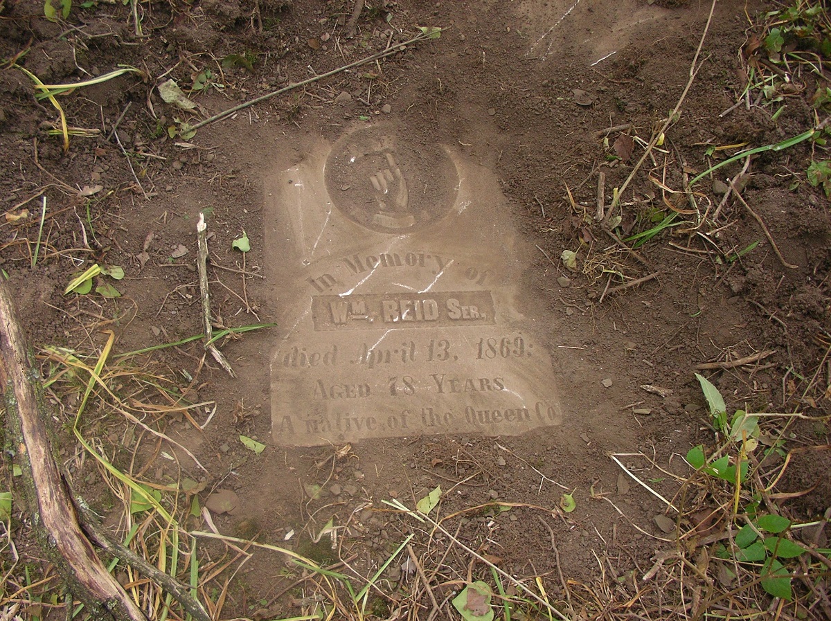
From an Indenture dated March 5, 1885 between the Reverend George Innes, Thomas Herbert Marsh, William John Reid, church wardens of Saint Paul’s Church. “Lot #9 and lots #23 to 28 inclusive according to a survey of a portion of that part of the North half of lot #11 in Concession C in the township of London heretofore known as Saint Paul’s Cemetery made by Charles A. Jones P.L. S. For the Rector and Church wardens of Saint Paul’s Church in the said city of London a map or plan whereof has been registered in the Registry office for the North and East Ridings of the County of Middlesex as #411. Also lots #10 to 16 inclusive lots #29 to 35 inclusive and lots # 42 to 48 inclusive according to a survey of another portion of Saint Paul’s Cemetery made by Charles A. Jones P.L.S. For the said Rector and Church Wardens a map or plan whereof has been registered in the said Registry Office as #413. Also such portions of that part of the said Cemetery bounded on the East by Queens Park on the South by York St. On the West by Rectory St. And on the North by the lane as shown on the plan #411 now unoccupied by the remains of the dead and which may hereafter from time to time become unoccupied by such remains reserving however out of said last mentioned parcel King St. Produced from Rectory St. To Queens Park and also the street lying between lots #13 and 14 on plan to 413 produced to York St.
My ancestor, Henry Sovereene/Sovereign murdered his wife and 7 of his children and was imprisioned in the London Jailhouse built in 1829. until his death by hanging on August 13, 1832, in London, Ontario, Canada, at the age of 44, and was buried in the London Jail Yard Cemetery. He was the second person to be hung there.